Congratulations to PhD student Marius Hogräfer, postdoc Jens Emil Grønbæk, research assistant Jana Puschmann, videographer Sebastian Krog Knudsen, and associate professor Hans-Jörg Schulz who won the 2022 Cybercartography Competition at AGILE’22 Conference on Geographic Information Science. Their entry submission “MapBlender: Enabling Collaborative Cybercartography” convinced the jury and won them the first price.
We have asked PhD student Marius Hogräfer to tell us some more about the competition and their submission.

The goal of the competition (http://cybercarto.ntua.gr/events/competition2022/) was to showcase novel tools and advancements in cybercartography from a practical perspective. Cybercartography is a relatively young research field that looks at how emerging technologies affect the way in which we work with maps, for example how it affects the way in which we access and analyze geospatial data, or how new technologies enable us to collaborate through and with maps across workspaces. After the announcement of the competition, teams from any background could submit a cybercartographic application along with some documentation, and potentially a short paper on the scientific background.
Even though it is one of the original goals of cybercartography, a big challenge that remains is collaboration. What we saw a lot when reviewing the literature, in the field, is that collaboration is restricted to a single cartography tool, or that all that is available for communicating is a simple chat window. This is of course a limitation, given that we are moving towards workspaces that are more distributed, which means that people have to communicate, share, and work together closely, even when they are not in the same room or country. We saw this as an opportunity for bringing in our expertise as HCI researchers, and addressing this fundamental challenge: How can we bring people together, enabling them to collaborate across tools AND workspaces, in an easy to use, low-barrier way?
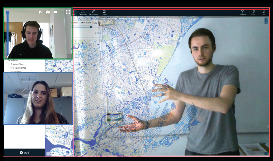
Our submission to the competition is called MapBlender. At its core, MapBlender is a video conferencing platform that allows all people in a meeting to share their screens and camera feeds, and to freely resize and rearrange them on a workspace that is synchronized between all meeting participants. They can also blend their shared windows, so that the content between them becomes visible. This means people can not only just see and present what they are currently working on, but they can also overlay, compare, and collaborate across multiple tools. Our demo video shows this in action.
And here’s why this is important for collaborative cybercartography: First, people in a meeting can share any cybercartography tool they like. From a technical perspective, this guarantees that MapBlender is tool-independent, but it also means that diverse teams of people with different backgrounds and preferences can easily work together on MapBlender. Second, since people are working with geospatial data, blending their tools with each other means that people can now view the data from one tool in context of the data in another tool, of course granted that both show the same region on Earth. This fosters collaboration, because people can now compare their work within two instances of the same tool, but they can also discuss and analyze their data in the context of different tools. A third benefit of MapBlender is that people can just open their browser and join a session, so no local installation is necessary, and as long as people are using modern browsers, MapBlender is also platform independent.
Even though it is one of the original goals of cybercartography, a big challenge that remains is collaboration. What we saw a lot when reviewing the literature, in the field, is that collaboration is restricted to a single cartography tool, or that all that is available for communicating is a simple chat window. This is of course a limitation, given that we are moving towards workspaces that are more distributed, which means that people have to communicate, share, and work together closely, even when they are not in the same room or country. We saw this as an opportunity for bringing in our expertise as HCI researchers, and addressing this fundamental challenge: How can we bring people together, enabling them to collaborate across tools AND workspaces, in an easy to use, low-barrier way?
Our submission to the competition is called MapBlender. At its core, MapBlender is a video conferencing platform that allows all people in a meeting to share their screens and camera feeds, and to freely resize and rearrange them on a workspace that is synchronized between all meeting participants. They can also blend their shared windows, so that the content between them becomes visible. This means people can not only just see and present what they are currently working on, but they can also overlay, compare, and collaborate across multiple tools. Our demo video shows this in action.
And here’s why this is important for collaborative cybercartography: First, people in a meeting can share any cybercartography tool they like. From a technical perspective, this guarantees that MapBlender is tool-independent, but it also means that diverse teams of people with different backgrounds and preferences can easily work together on MapBlender. Second, since people are working with geospatial data, blending their tools with each other means that people can now view the data from one tool in context of the data in another tool, of course granted that both show the same region on Earth. This fosters collaboration, because people can now compare their work within two instances of the same tool, but they can also discuss and analyze their data in the context of different tools. A third benefit of MapBlender is that people can just open their browser and join a session, so no local installation is necessary, and as long as people are using modern browsers, MapBlender is also platform independent.
Most importantly, we are a diverse team consisting of a PhD student, a Postdoc, a Research Assistant, a videographer, and an Associate Professor, so everybody could contribute their strengths and expertise to the project, and we could divide the work between us. This meant that in the end, not only did we submit a running prototype, but also a short paper, a demo video, a project website, and a user guide, and we think this “full package” played a big part in convincing the jury.
We also had help from Peder Bøcher from SCALGO, a spin-off company from the Algorithms research group. Their flood risk assessment platform can quickly simulate how heavy rainfall and rising sea levels will affect an environment, and allows analysts to plan drainages of these water masses towards areas where they won’t damage property or pose any risk to people. Peder helped us immensely in showcasing our submission, by using MapBlender to facilitate a hybrid teaching scenario.
Lastly, we didn’t have to start from scratch. Our work is based on a previous research paper called MirrorBlender that was also developed here at Aarhus Univesrity. Since the MirrorBlender software is open source, it made for a great starting point for our submission.


